
Executive Overview
This multi-million-dollar acquisition underscores a broader, fundamental shift in how the technology and crypto sectors view the physical world. While recent years have been dominated by software-based generative AI and large language models (LLMs) commoditizing digital intelligence, the next major evolutionary frontier is "Physical AI." As millions of autonomous vehicles, delivery drones, industrial robots, and humanoid assistants prepare to flood global markets, they face a shared, mission-critical bottleneck: spatial awareness.
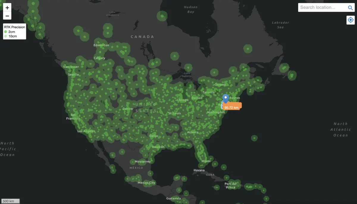
To operate safely and efficiently, these decentralized autonomous systems require sub-centimeter positioning accuracy—a standard far beyond the capabilities of conventional, consumer-grade GPS. Enter Geodnet, the world’s largest precision positioning network. By utilizing DePIN tokenomics to incentivize independent operators to install Real-Time Kinematics (RTK) base stations, Geodnet has upended the traditional, capital-heavy cost structures of legacy geospatial corporations. Boasting over 13,000 active base stations across 142 countries and a rapidly scaling enterprise demand-side revenue run-rate of approximately $3M annually, Geodnet has achieved "threshold scale." This strategic investment by Multicoin validates the network’s production-grade capabilities and signals that the physical infrastructure required to anchor autonomous systems is finally scaling to meet demand.
Detailed Chronology: From Concept to Global Scale
The rapid ascent of the Geodnet Network did not happen overnight. It represents the culmination of targeted execution, hardware optimization, and the practical application of token-incentivized distributed networks.

Building the Foundations
Founded by industry veteran Mike Horton, Geodnet set out to solve a multi-billion-dollar geospatial challenge: providing high-precision GNSS (Global Navigation Satellite System) corrections without the exorbitant capital expenditures historically demanded by legacy utility providers. Traditional enterprise positioning networks relied on centralized entities—such as Trimble, Hexagon, and Topcon—to survey land, purchase expensive proprietary hardware, and construct isolated base stations. These high fixed costs were subsequently passed down to end users through prohibitive enterprise software and hardware fees, limiting precision positioning primarily to high-margin industrial applications.
Recognizing the structural limitations of centralized rollouts, Geodnet turned to the nascent design space of DePIN. By issuing the GEOD token, the network created a mechanism to crowdsource the deployment of hardware. Instead of paying corporate field teams to set up base stations, Geodnet incentivized independent individuals and small businesses to purchase, install, and maintain consumer-grade RTK base stations (such as triple-band GNSS units) in exchange for token rewards.
Scaling Milestones
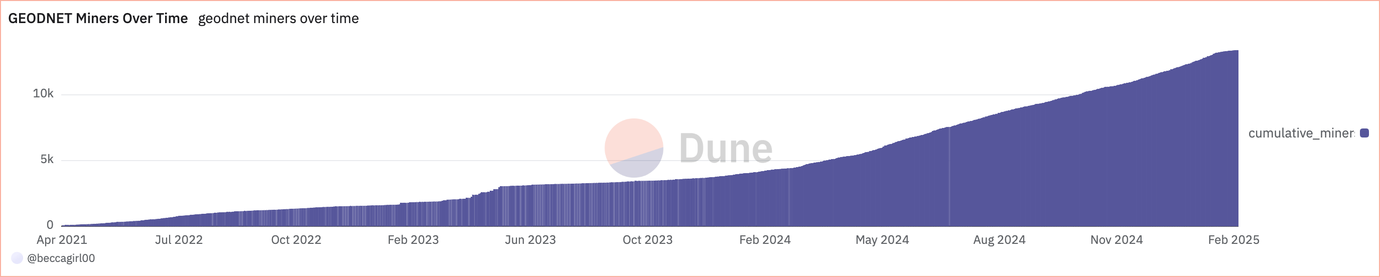
The efficacy of this crowdsourced model became evident through aggressive, compounding growth metrics over the past three years:
- November 2022: The network established a foundational footprint with approximately 1,400 active base stations globally.
- June 2024: Driven by organic community adoption and expanding enterprise utility, the network scaled rapidly to 7.8 thousand base stations.
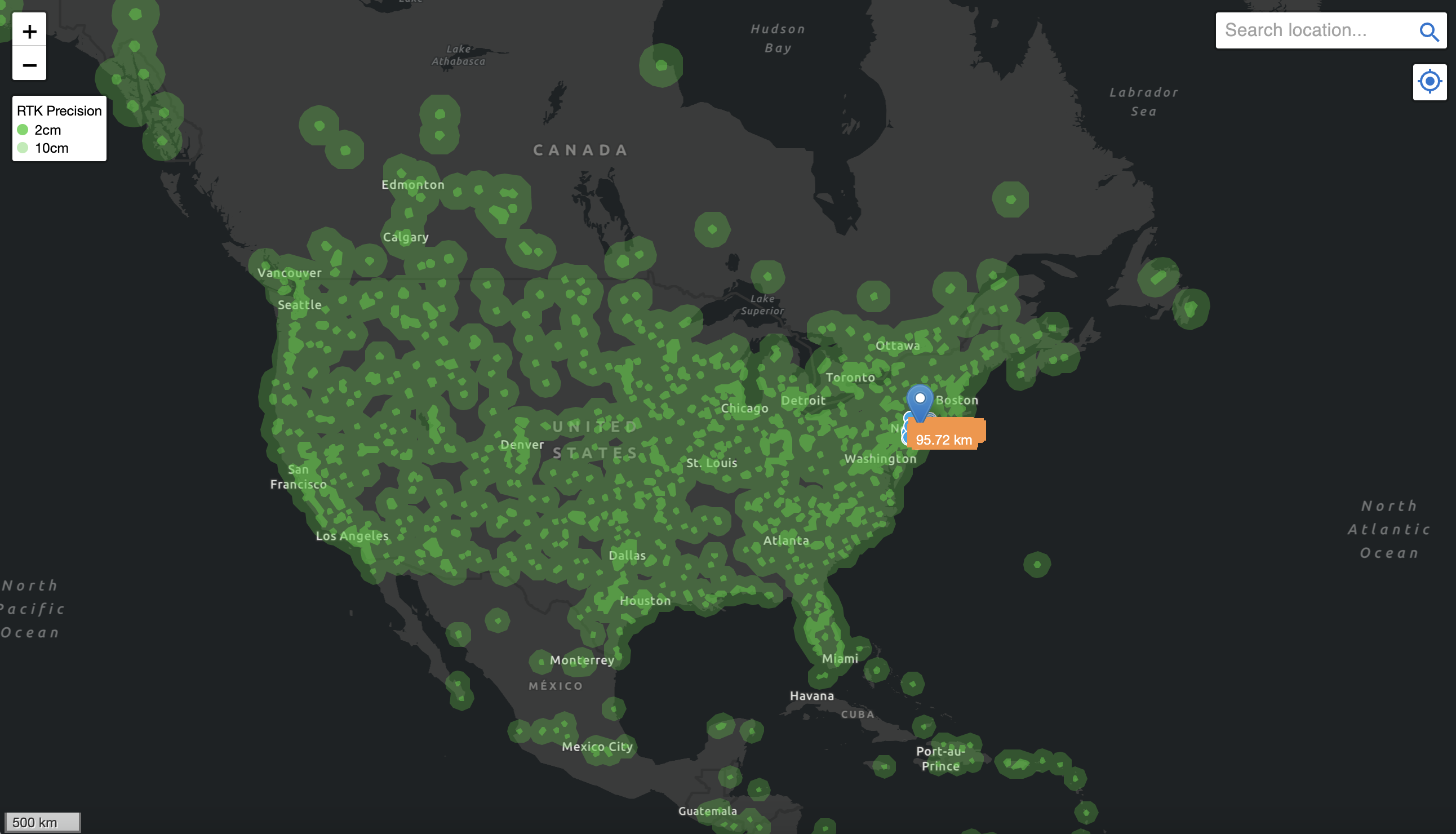
- January 2025: Geodnet surpassed 13,000 active base stations strategically deployed across 4,377 cities in more than 142 countries.
Crucially, this global scale was achieved with remarkable capital efficiency. Data indicates that only 11% of the total GEOD token supply has been emitted to network contributors over its three-year operational history. This lean token-emission schedule has allowed Geodnet to achieve what decentralized infrastructure analysts call "threshold scale"—a density of coverage sufficient to service more than 60% of the addressable global GNSS corrections market.
Supporting Context & Metrics: Solving the $5B Localization Problem
As global industries race toward full automation, the challenge of spatial awareness has transformed into a multi-billion-dollar economic hurdle. According to market data from the European Union Agency for the Space Programme (EUSPA), localization is a foundational $5B problem that underpins the entire robotics and autonomous vehicle ecosystem.
The Limits of Standard GNSS and Sensor Fusion
Standard GNSS positioning—the technology embedded in smartphones and basic navigation systems—is inherently prone to environmental interference, atmospheric anomalies, and multipath errors caused by urban canyons. These limitations result in positional deviations of 5 to 10 meters, rendering standard GPS useless for precision robotics.
To compensate, modern autonomous systems rely on complex sensor fusion arrays:
- LiDAR (Light Detection and Ranging): Delivers high-resolution depth mapping, but remains heavy, power-hungry, expensive, and severely degraded by adverse weather conditions like heavy fog or rain.
- RADAR: Offers robust object distance measurement, but lacks the fine-grain spatial precision required for centimeter-level maneuvering.
- Vision-Based SLAM (Simultaneous Localization and Mapping): Enables real-time environment mapping, but suffers performance degradation in low-visibility or dynamic environments.
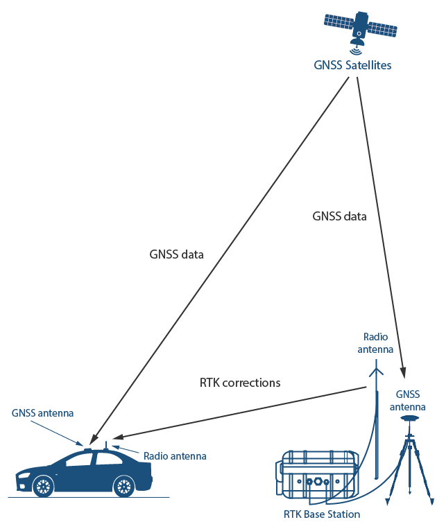
Because no single sensor suite is entirely foolproof, industrial automation leaders—including DJI for high-precision drones, John Deere for autonomous agricultural tractors, Tesla for self-driving vehicles, and Boston Dynamics for industrial inspection robots—integrate Real-Time Kinematics (RTK) base stations into their workflows. RTK technology compares satellite signals against a known fixed geographic point, transmitting real-time correction data that shrinks positional error down to sub-centimeter levels.
[Satellites] ---> [Standard GNSS (5-10m Error)] ---> [Atmospheric / Multipath Interference]
       │
       └──> [GEODNET RTK Base Stations] ---> [Real-Time Correction Data] ---> [Sub-Centimeter Precision for Physical AI]
Inverting the Cost Structure
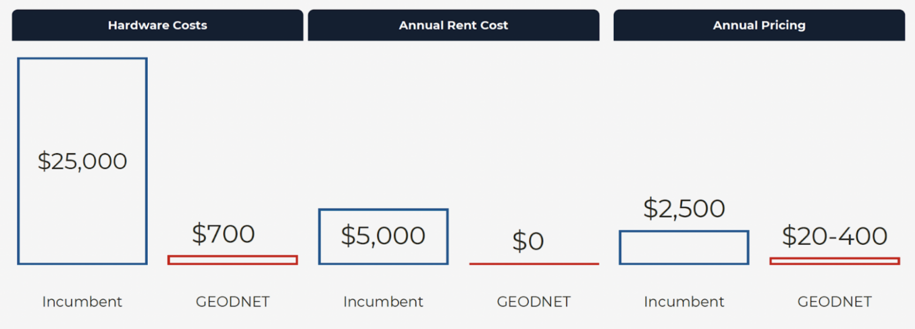
While RTK is the gold standard for localization, legacy providers have historically priced out smaller fleets and developers. Enterprise-grade RTK stations can cost upwards of $12,000 per unit, while annual data subscription fees run into the thousands per tracked device.
Geodnet inverts this traditional cost structure through its decentralized architecture. By eliminating the two primary capital expenditures associated with network expansion—land acquisition and labor—Geodnet delivers production-grade positioning hardware at a fraction of legacy costs. For instance, a consumer-grade GEODNET miner retails around $700, yet when deployed in a dense, crowdsourced mesh, it yields equivalent or superior coverage compared to legacy enterprise stations.
Consequently, annual subscription pricing for end users is an order of magnitude lower. This drastic reduction in overhead has catalyzed rapid adoption among enterprise clients, driving Geodnet’s annualized on-chain revenue to approximately $3 million. Major commercial entities, including Propeller Aero, DroneDeploy, Quectel, and the United States Department of Agriculture (USDA), now rely on the network for mission-critical positioning feeds.
Official Statements and Industry Perspectives
The convergence of decentralized finance, cryptographic incentives, and hard-tech robotics has attracted significant attention from venture investors and protocol architects alike. Shayon Sengupta, writing in recent Multicoin analytical publications regarding agentic infrastructure, noted that the evolution of AI is no longer confined to digital chat windows and media generation engines; it is rapidly spilling over into the physical world.
In early strategic discussions with Geodnet founder Mike Horton, investors consistently pressed on a singular operational question: How has a decentralized network managed to onboard tier-one autonomous vehicle, drone, and agricultural robotics clients at such an accelerated pace?
The answer, according to network leadership, lies entirely within structural cost arbitrage. By leveraging DePIN tokenomics, Geodnet bypassed the grueling, balance-sheet-heavy capital expenditure cycles that crippled traditional geospatial startups. Instead, it aligned global economic incentives so that individual contributors deployed hardware organically where it was most needed.
The $8M strategic token acquisition by Multicoin acts as a powerful endorsement of this thesis. By securing a major treasury allocation of GEOD tokens, institutional capital is directly backing the infrastructure layer that will anchor autonomous software agents to physical coordinates.
Future Outlook: The Dawn of Physical AI
As the technological landscape heads toward the latter half of the decade, the integration of generative AI models with physical hardware is transitioning from theoretical speculation to commercial reality. Industry forecasts point to the deployment of tens of millions of specialized robots across global supply chains over the coming years.
Drones will execute autonomous, real-time grid inspections of electrical infrastructure and cross-country pipelines. Automated agricultural implements will manage crop yields with millimeter precision, minimizing resource waste. Urban logistics will see autonomous delivery fleets navigating dense pedestrian zones, while early-generation humanoid robots begin assisting with industrial manufacturing and household operations.
None of these futuristic use cases can succeed without absolute spatial certainty. Autonomous systems cannot guess where they are; they must know their coordinates with unyielding precision. While legacy correction services remain sluggish, expensive, and geographically restricted, Geodnet has proven that decentralized economic incentives can build faster, denser, and more cost-effective global infrastructure than centralized corporate monopolies.
The question surrounding the mass deployment of AI-driven robotics is no longer a matter of if, but when. And as millions of autonomous machines prepare to awaken across the globe, the Geodnet Network ensures that humanity will always know precisely where they are.